
Positioning & heading
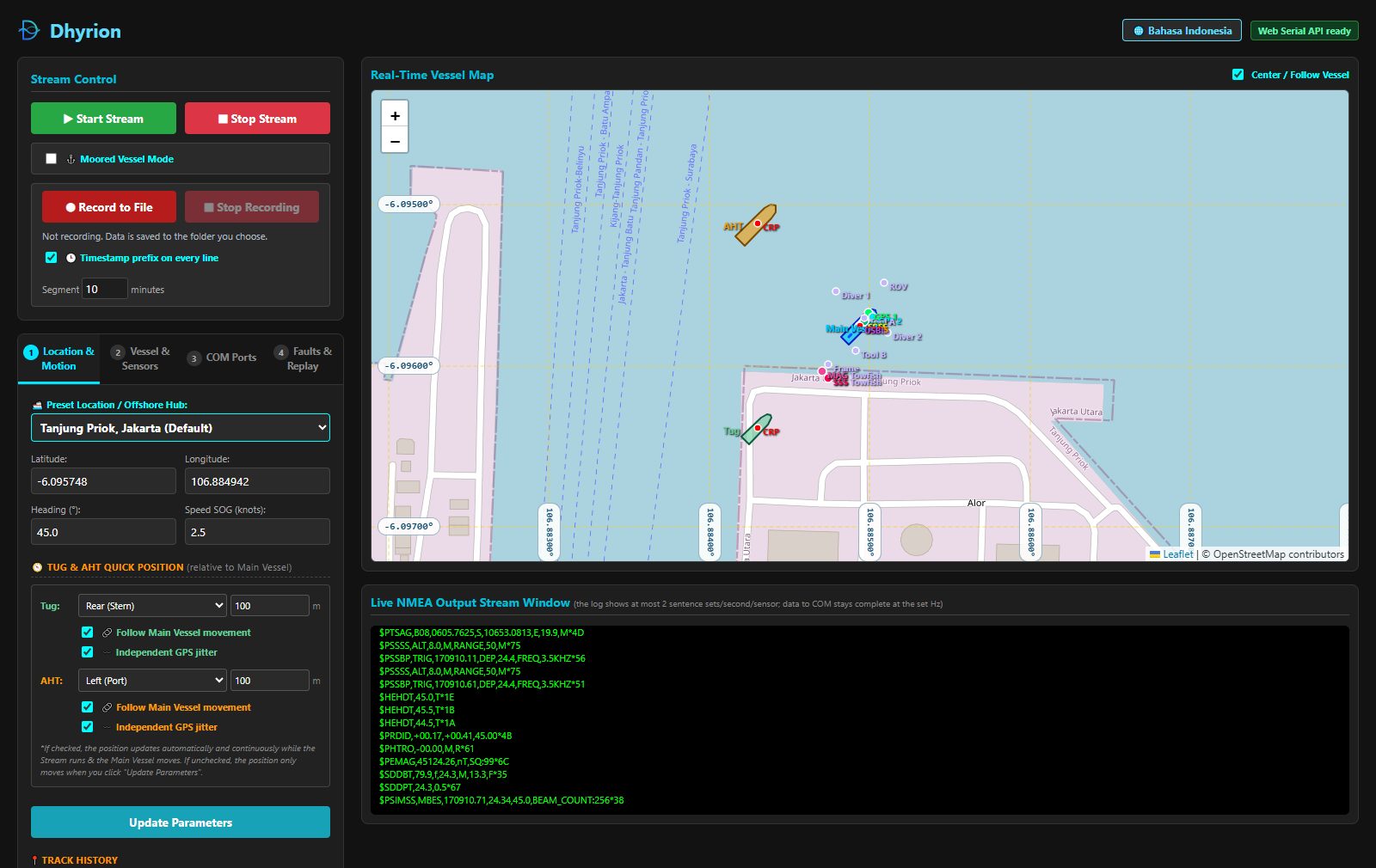
GPS 1 and GPS 2 on the main vessel, plus independent GPS and gyro for the Tug and AHT. Antenna positions follow your sensor offsets and vessel heading, so the positions in GGA and RMC are where the antennas really are.
Runs in Chrome & Edge, nothing to install
Dhyrion streams realistic data from 21 survey sensors (GPS, gyro, motion, echosounders, sonar, magnetometer and USBL beacons) straight to your navigation software. Test setups, train operators and rehearse faults without a vessel.
Features
One main vessel with a tug and an anchor handling tug, each with its own GPS and gyro, plus the full acoustic and geophysical sensor set.
GPS 1 and GPS 2 on the main vessel, plus independent GPS and gyro for the Tug and AHT. Antenna positions follow your sensor offsets and vessel heading, so the positions in GGA and RMC are where the antennas really are.
Roll, pitch and heave that move like a real hull in calm to moderate sea, not random jumps.
SBES, MBES and SBP read a seabed that changes smoothly, corrected for each transducer's draft.
Eight targets (ROV, divers, tools, towfish) that drift on their own and never sink below the seabed.
Side scan sonar and magnetometer follow the USBL beacon you link them to, including altitude.
Throw real-world problems at your operators and your software: signal dropout, RTK fix dropping to float, multipath position jumps, depth spikes, gyro drift, corrupted checksums, packet loss and latency. Every fault can switch itself off after a set time.
Play back a real survey log to any port, timed by its own timestamps, at 0.5x to 10x.
Saves exactly what was sent, one file per sensor with an optional UTC timestamp on every line, plus a "truth" CSV of the real position, heading and depth without noise or faults. Compare the two to QC how your software handled the data.
Vessels, antennas, transducers and beacons drawn to scale on OpenStreetMap, with a lat/lon grid and a distance and bearing tool.
The simulator
See every vessel, antenna, transducer and beacon on a live map while the NMEA stream scrolls beside it. Start at one of 20 ports and offshore hubs worldwide, or enter your own coordinates.
How it works
Choose a location, enter vessel dimensions and the X/Y/Z offset of every sensor from the CRP. A live drawing shows the geometry as you type.
Click Connect next to a sensor and pick a COM port. Use a physical serial port, or a virtual COM pair (for example com0com) to feed software on the same PC.
Each sensor sends at its own rate, up to 50 Hz. Point your navigation software (EIVA NaviPac or any program that reads NMEA) at the other end of the port.
Need UDP or TCP? Browsers cannot open network sockets, so UDP, TCP client and TCP server output go through the small Python relay that comes with Dhyrion. Run it on your own PC; it is switched off on the online version for security.
Output
Standard NMEA 0183 where it exists, common proprietary formats where it does not. All sentences carry a valid checksum.
| Sensor | Sentences | Default rate |
|---|---|---|
| GPS 1 (Primary) | $GPGGA $GPRMC | 1 Hz |
| GPS 2, GPS Tug, GPS AHT | $GNGGA / $GPGGA | 1 Hz |
| Gyro Main, Tug, AHT | $HEHDT | 10 Hz |
| Motion / MRU | $PRDID $PHTRO | 10 Hz |
| SBES | $SDDBT $SDDPT | 5 Hz |
| MBES | $PSIMSS | 5 Hz |
| Side scan sonar | $PSSSS | 2 Hz |
| Magnetometer | $PEMAG | 10 Hz |
| Sub-bottom profiler | $PSSBP | 2 Hz |
| USBL beacons B01-B08 | $PTSAG | 1 Hz |
FAQ
Google Chrome or Microsoft Edge on a desktop or laptop. Dhyrion uses the Web Serial API to talk to COM ports, which Firefox and Safari do not support. The map and the stream still run elsewhere, but you cannot connect a port.
No. Open the simulator and connect a port. You only need extra software for a virtual COM pair (to feed a program on the same PC) or the Python relay (for UDP/TCP output).
No. The simulation runs entirely in your browser, and data goes straight from the browser to your COM port. Recordings are saved to a folder you choose on your own computer.
Yes. Fault injection lets you trigger dropouts, degraded GPS fixes, position jumps, depth spikes, gyro drift and corrupted data on purpose, and switch them off automatically after a set time.
Yes. Load a NMEA log file and send it to any sensor port. Timing follows the timestamps in the file, or a fixed interval if it has none.
Open the simulator, connect a COM port and start streaming in under a minute.
Open Simulator